


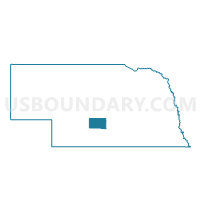
Overton Precinct, Dawson County, Nebraska
About
Outline

Summary
| Unique Area Identifier | 612690 |
| Name | Overton Precinct |
| County | Dawson County |
| State | Nebraska |
| Area (square miles) | 121.26 |
| Land Area (square miles) | 119.30 |
| Water Area (square miles) | 1.96 |
| % of Land Area | 98.38 |
| % of Water Area | 1.62 |
| Latitude of the Internal Point | 40.77690920 |
| Longtitude of the Internal Point | -99.51610950 |
Maps

Graphs
Select a template below for downloading or customizing gragh for Overton Precinct, Dawson County, Nebraska


Neighbors
Neighoring Voting District (by Name) Neighboring Voting District on the Map
- Elm Creek Precinct, Buffalo County, NE
- Grant Precinct, Dawson County, NE
- Platte Precinct, Dawson County, NE
- R-1 Precinct, Buffalo County, NE
- Westside - Willaimsburg Precinct, Phelps County, NE
- Woodriver Precinct, Dawson County, NE
Top 10 Neighboring County Subdivision (by Population) Neighboring County Subdivision on the Map
- Elm Creek township, Buffalo County, NE (1,242)
- Overton precinct, Dawson County, NE (1,144)
- Grant precinct, Dawson County, NE (627)
- Platte precinct, Dawson County, NE (613)
- Wood River precinct, Dawson County, NE (459)
- Armada township, Buffalo County, NE (249)
- Williamsburg township, Phelps County, NE (153)
- Westside township, Phelps County, NE (131)
- Logan township, Buffalo County, NE (114)
Top 10 Neighboring Place (by Population) Neighboring Place on the Map
Top 10 Neighboring Unified School District (by Population) Neighboring Unified School District on the Map
- Lexington Public Schools, NE (12,327)
- Holdrege Public Schools, NE (6,994)
- Elm Creek Public Schools, NE (1,596)
- Bertrand Public Schools, NE (1,433)
- Overton Public Schools, NE (1,248)
- Sumner-Eddyville-Miller Schools, NE (947)
Top 10 Neighboring State Legislative District Upper Chamber (by Population) Neighboring State Legislative District Upper Chamber on the Map
- State Senate District 36, NE (37,224)
- State Senate District 44, NE (33,011)
- State Senate District 38, NE (32,734)
Top 10 Neighboring 111th Congressional District (by Population) Neighboring 111th Congressional District on the Map
Top 10 Neighboring Census Tract (by Population) Neighboring Census Tract on the Map
- Census Tract 9690, Buffalo County, NE (4,103)
- Census Tract 9689, Buffalo County, NE (3,555)
- Census Tract 9672, Phelps County, NE (3,271)
- Census Tract 9680, Dawson County, NE (2,584)
Top 10 Neighboring 5-Digit ZIP Code Tabulation Area (by Population) Neighboring 5-Digit ZIP Code Tabulation Area on the Map
- 68850, NE (12,295)
- 68836, NE (1,688)
- 68927, NE (1,164)
- 68863, NE (1,151)
- 68878, NE (446)
- 68858, NE (266)